Backcountry fishing candidate
Kennedy Meadows → Summit Creek / Granite Dome
Best fit for: shortest practical drive, granite, Emigrant Wilderness solitude, and stream fishing. Plan on roughly 6 miles in on Day 1, then a shorter Day 2 move toward timberline.
Drive~3h 34m from Dublin to Kennedy Meadows, no traffic.
TrailheadKennedy Meadows, Highway 108.
DatesSeptember 24–27.
RouteKennedy Meadows → Relief / Summit Creek zone → higher timberline camp → Granite Dome day hike → descend toward Relief Reservoir for final night.
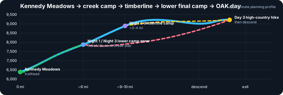
Elevation~6,400 ft start; ~9,000–9,400 ft high granite zone.
PermitFree Stanislaus wilderness permit; simpler than Yosemite.
Fit
Why it fits: no motorized/mechanized travel inside Emigrant Wilderness, strong granite country near Granite Dome, and actual moving-water options on Relief Creek / Summit Creek.
Caveat: Treat Summit Creek / Relief Creek as the Day 1 moving-water target. The near-timberline payoff comes from a shorter Day 2 move another 3–4 miles higher, but the Oakland flight constraint means Day 3 should end lower, back toward Relief Reservoir, so Day 4 is not too risky.
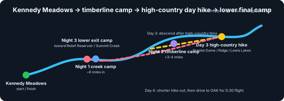
Route concept
Hiking elevation profile
Approximate planning profile: Kennedy Meadows ~6,400 ft; Day 1 camp about 6 miles in near the Relief / Summit Creek zone; Day 2 move another 3–4 miles toward timberline around ~8,800–9,200 ft; Day 3 day hike the high country, then descend back toward Relief Reservoir for the final night; Day 4 is a shorter exit plus the drive to OAK.
3-night itinerary — morning drive Day 1
Day 1 — Thu Sep 24 — Dublin → Kennedy Meadows → creek camp, ~6 miles in
Drive in the morning. Hike roughly 6 miles from Kennedy Meadows into the Relief / Summit Creek corridor and camp legally near moving water. This keeps Day 1 realistic while still getting beyond the trailhead approach.
~6 mi hikestream camp
Day 2 — Fri Sep 25 — Move 3–4 miles higher toward timberline
Break camp and continue another 3–4 miles toward the higher Granite Dome / Lewis Lakes zone. Set a second camp near timberline where there is water and legal camping, then fish nearby outlet, inlet, or upper-creek water as conditions allow.
3–4 mi movenear timberline
Day 3 — Sat Sep 26 — High-country day hike, then descend toward Relief Reservoir
Break or stage camp early enough to day hike toward Granite Dome, Ridge Lake, Lewis Lakes, or nearby high basins, then move back down toward the Relief Reservoir / lower Summit Creek corridor for the final night. This protects the Day 4 airport timeline.
day hikedescend for exit
Day 4 — Sun Sep 27 — Shorter hike out → Oakland airport
Hike out from the lower Relief Reservoir / Summit Creek side camp to Kennedy Meadows, then drive to Oakland airport for a 5:30 flight. Assume roughly 4 hours of no-traffic driving from Kennedy Meadows to OAK; the safer plan is to have already descended on Day 3 and still start early on Day 4.
5:30 flightlower final camp
Late September temperature planning
Day 1 — Thu Sep 24 — creek camp around ~8,200 ft
Plan for daytime highs roughly 50–65°F and overnight lows around 28–38°F. A mild night could stay near 40°F, but do not plan on a 50°F low.
Day 2 — Fri Sep 25 — move toward timberline, ~8,800–9,200 ft
Plan for highs roughly 45–60°F and lows around 25–35°F, colder if the camp is exposed, windy, or in a cold-air drainage.
Day 3 — Sat Sep 26 — high-country day hike, then lower camp
High-country daytime conditions may be 45–62°F. The final night should be somewhat lower and less exposed than the timberline camp, but still plan for a cold overnight: roughly 28–38°F.
Day 4 — Sun Sep 27 — shorter hike out
Expect a cold morning start from the lower camp, then warmer hiking as the route drops: roughly 50–65°F by afternoon, depending on elevation and cloud cover.
Conservative late-September planning range, not a live trip-date forecast. Open-Meteo historical reanalysis for roughly Sep 20–30 near the Summit Creek / Granite Dome coordinates shows median lows in the mid-40s, but the cold tail reaches freezing and below; actual camps at 8,200–9,200 ft can run much colder because of elevation, exposure, and cold-air pooling. Re-check the NWS/Open-Meteo point forecast within a few days of departure.
Moon / night light
Thu Sep 24 — waxing gibbous, 96% lit
Moonset 4:40 AM; moonrise 5:54 PM; upper transit 11:44 PM. Bright evening moonlight after sunset.
Fri Sep 25 — waxing gibbous, 99% lit
Moonset 5:44 AM; moonrise 6:18 PM. Very bright night; nearly full moon.
Sat Sep 26 — full moon, 100% lit
Full moon at 9:49 AM. Moonset 6:50 AM; moonrise 6:43 PM; upper transit 12:29 AM. Brightest night of the trip.
Sun Sep 27 — waning gibbous, 98% lit
Moonset 7:58 AM; moonrise 7:09 PM; upper transit 1:15 AM. Bright moon, but it rises after the airport-day evening window.
Moon times are for the approximate Summit Creek / Granite Dome coordinates in local Pacific time, from the U.S. Naval Observatory rise/set API. The trip is essentially full-moon conditions, so expect substantial night light but less dark-sky viewing.
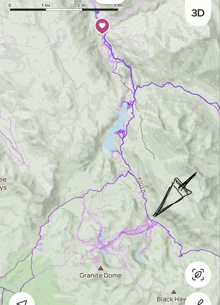
Night 1 camp map note
Night 1 target: camp in the Summit Creek / Relief Valley corridor, roughly 6 miles in, near the 8,200 ft zone. The arrowed spot is the right general area, but treat it as approximate: the exact arrow tip looks a little east of the main creek/trail corridor, more like a side bench with small tarns or ponds. For a true Summit Creek camp, look slightly west or southwest toward the main drainage/trail where flatter valley floor, moving water, and durable legal campsite options come together. Avoid wet meadow or fragile creekside ground.
Fishing notes
- Primary stream targets: Relief Creek / Summit Creek on Day 1, upper outlet/inlet or creek water from the timberline camp on Day 2–3, then lower Relief / Summit Creek water again after descending for the final night.
- Granite Dome lakes can add trout action, but this should not become a lake-only trip.
- Best unknown to verify: which lower final-night camp near the Relief Reservoir / lower Summit Creek side gives a legal, durable site and a realistic Day 4 exit to OAK.
Photos
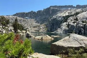
Granite Dome from Ridge Lake: granite boulders, alpine water, sparse high-country vegetation.
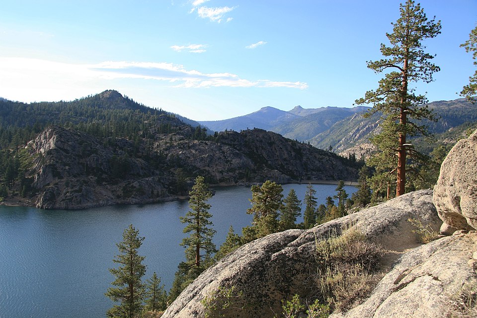
Relief Reservoir: approach landmark, not the target camp.
Sources
← Backcountry Fishing